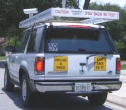
Mobile imaging system assesses and maps pavement conditions
Southeastern Surveying and Mapping Corp. (SSMC; Orlando, FL, USA) has developed a mobile imaging system to acquire, assess, and map roadway pavement conditions for city and county agencies. In the past, manual surveys have been used to collect pavement distress data, but these surveys are labor and time intensive, and data reliability depends on training and inspector performance.
To collect the imagery, the SSMC team worked with the staff ofNorPix (Montreal, QC,Canada) to develop a Mobile Imaging Vehicle equipped with two 1.3-Mpixel Prosilica GC1350CGigE Vision color cameras from Allied Vision Technologies (Stadtroda, Germany), running at up to 10 frames/s and connected to an on-board computer linked to a submeter GPS receiver. One camera looks forward for an overall right-of-way view and a second camera at the rear is pointed down at the pavement to capture a wide-angle pavement view. This system allows the team to drive at posted speeds and collect images from each camera at intervals of 5 to 10 ft.
Each image is tied to a GPS position using theNorpix StreamPix GPS Positioning Module to show where the camera was located when the image was captured. The coordinates of the image calibration points are measured to establish the relationship between the vehicle and its orientation with respect to the features in the image on the ground.
This relationship of image coordinates to ground coordinates can be calculated as an image transformation to warp and flatten the original image onto the surface of ageographical information system (GIS) map. By applying this transformation to the image, the image can be displayed in its true ground orientation on the GIS map to locate and measure the dimension of features on the ground.
SOURCE:NorPix
Posted by Conard Holton
Vision Systems Design
