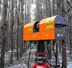
Lidar-based scanner forecasts forest carbon stores
As part of a collaborative project with Boston University (Boston, MA, USA), researchers at CSIRO (South Victoria, Australia) have been scanning Jeffrey pine trees in the US with a ground-based laser scanner called ECHIDNA to estimate how much plant material forests have.
The ECHIDNA is a light detection and ranging (lidar) instrument that works by directing thousands of laser pulses into the forest and recording the energy that bounces back over time.
In use, the instrument records the location and distance to each reflection, enabling its precise location in 3-D space to be calculated. Importantly, the intensity of the reflected energy can also be used to differentiate between ground, foliage, and tree stems.
Data collected from the ECHIDNA laser scanner were analyzed to estimate the size and number of trees in each site that was scanned. Based on the information gathered about tree size and amount of plant material, it was then possible to estimate carbon stocks, or the amount of carbon stored in a forest.
The ground-based laser scanning data has also been combined with satellite imagery as part of a broader project to map forest carbon stocks at a continental scale.
-- By Dave Wilson, Senior Editor, Vision Systems Design
