Vision takes flight in commercial unmanned aerial vehicles
Recent changes at the Federal Aviation Administration have opened opportunities for drones or unmanned aircraft systems (UAS) to be used in commercial applications.
Frank J. Vallese
Drones, also known as unmanned aerial vehicles (UAV) or unmanned aircraft systems (UAS) are commonly used in military applications. Advances in commercial uses of UASs in the United States, however, have been limited because of regulations on the use of airspace and privacy concerns. Now with new U.S. airspace policy, commercial markets are developing quickly as businesses are finding a diversity of applications.
The challenge for the Federal Aviation Administration (FAA; Washington, DC, USA; www.faa.gov) which oversees the use of the nation's airspace has been to develop a framework of rules designed to regulate how these vehicles are used without undermining the growth of drone technology for commercial applications. In early 2015, the FAA released an interim policy for commercial UAS operators that was a significant improvement over the previous process that required every commercial UAS operation be individually evaluated.
The new interim policy (associated with Section 333 of the FAA Modernization and Reform Act of 2012) permits businesses to apply for an exemption that enables them to fly small UAS (sUAS) for specific commercial uses under certain defined parameters without the previous level of government oversight. The FAA's exemptions designate guidelines for commercial drone operators to fly sUAS lighter than 55lbs with certain restrictions.
The most significant restriction is the requirement that the drone operator must have an FAA-issued pilot's license and must operate the sUAS within their visual line of sight. Also, the sUAS are restricted to flying under a certain altitude above ground level (a minimum of 200ft and up to 400ft), operating only during daytime conditions, and avoiding restricted airspace regions such as near airports.
The interim FAA policy is expected to be only temporary as new rules (intended to be added as a new part 107 to Title 14 Code of Federal Regulations-14 CFR) are developed that allow for "routine civil operation of small UAS" in the National Airspace System and to provide rules to assure safety for those operations.
Proposed rules were published in the Federal Register on February 23, 2015, with a 60-day public comment period. Significant comments were received with some public controversy expressed. It is hoped that the new rules do not require that the drone operator has a full pilot's license and that an accommodation with pertinent training is accepted. It is expected that the FAA will publish a final rule in June 2016.
Until the final rule is published, the FAA will continue to process the Section 333 Exemption requests to permit otherwise prohibited commercial UAS flights. sUAS rules do not apply to those used for hobbyist or recreational purposes.
Commercial applications
The fast-growing commercial UAS industry is not waiting for the new rules to be finalized. As of December 2015, over 2,500 exemptions have been granted by the FAA for companies requesting permission to fly sUAS for commercial applications. Most of the applications involve drones equipped with cameras and sensors.
A spectrum of businesses is investigating the future commercial use of drones, from large organizations to small startups. Some drone hardware and software suppliers are supporting companies in several markets, including power transmission, construction, real estate and precision agriculture.
Perhaps the best known commercial application has been proposed by the online retailer Amazon (Seattle, WA; USA; www.amazon.com) that has been promoting the use of self-guided drones for systems designed to deliver packages safely within 30mins. Amazon has obtained an exemption to perform "Outdoor testing research and development" for its Prime Air initiative.
Of the other businesses with commercial exemptions, over 50% enable the operators to perform aerial photography and videography, 25% are for aerial surveying including mapping and agriculture and 10% are for tasks including power lines, roof and oil installation inspection.
Agricultural imaging
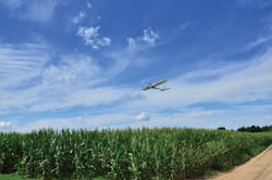
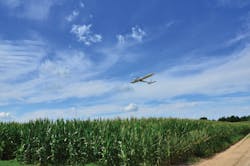
Besides Amazon's use for fast package delivery in urban areas, it is likely that many future commercial drones will operate far from large cities. Agriculture is seen as one of the most promising commercial markets for drones. Large rural areas with farms are a perfect fit for UAS technology where privacy and safety issues are less of a concern. As such, companies are equipping unmanned vehicles with cameras and other sensors to survey crops, monitor for disease or precision-sprayed pesticides and fertilizers (Figure 1).
One such company is Unmanned Sensing Systems (Mount Laurel, NJ, USA; www.unmannedsensing.com). Unmanned Sensing Systems was one of the first to receive an exemption for precision aerial survey operations for agricultural sensing in all 50 states and now provides a turnkey system for crop management companies seeking to perform aerial agricultural inspection such as crop stress assessment.
Vegetation stress
Crop management companies typically seek to maximize yield while minimizing the use of resources and reducing environmental impacts. Often maximizing plant health means early detection of vegetation stress that may indicate crop damage due to problems with irrigation, fertilization, weather or animal infiltration. The best approach to addressing such tasks depends on the specific application that will determine the selection of the UAV type, the camera sensor payload and the data gathering process.
Sensor-equipped UAVs can cover large territories areas quickly and safely. In general, fixed-wing drones (which are similar in design to passenger aircraft) are most common in these applications because they can fly over large distances for long periods. Alternatively, quadcopters and other rotary blade UASs that can hover in a fixed position are ideal for inspection of power lines or surveying hard-to-reach structures such as bridges.
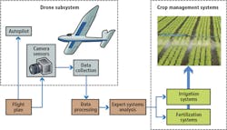
A variety of camera sensors can be used for these different applications. Unmanned Sensing Systems, for example, offers its clients a selection of three payloads: a visible camera such as a 1080p30 Hero camera rom GoPro (San Mateo, CA, USA; www.gopro.com), a customized NVDI multispectral camera and an uncooled thermal imaging camera ssuch as the Atom Thermal Camera from Sofradir EC Inc. (Fairfield, NJ; www.sofradir-ec.com). These cameras generate either a compressed or uncompressed raw digital imaging data stream that is captured by an onboard digital video recorder (Figure 2).
One popular method to detect crop stress is with a multispectral camera capable of producing images based on the Normalized Difference Vegetation Index (NDVI). These cameras acquire images in both the near-infrared (NIR) and visible bands. The images are combined to create an NDVI image where NDVI = (NIR-VIS)/(NIR+VIS) and VIS and NIR correspond to the spectral reflectance image data acquired in the visible and NIR spectral regions, respectively. Since healthy plants absorb visible radiation for photosynthesis and reflect NIR radiation (>700nm), these image files provide information that can help infer the level of photosynthesis occurring and thus the health of the vegetation.
Figure 3 shows an NDVI image of 6ft corn crops. The red circular patterns are due to the rotating irrigation system hardware. The other small red streaks are the result of significant tornado wind damage enough to justify an insurance claim. Without the aerial scan, the damage would never have been spotted since it was not visible from the area perimeter. Figure 3b shows a simulated 3D NDVI image combining the multispectral imagery with an orthomosaic of 3D data obtained using structure-from-motion (SfM) techniques. The encircled area shows significant damage due to trampling by wildlife into the crop area.
(b) A simulated 3D NDVI image combining the multispectral imagery with an orthomosaic of 3D data obtained using structure-from-motion (SfM) techniques. The encircled area shows significant damage due to trampling by wildlife into the crop area.">
Besides NDVI imaging, other cameras prove more useful in performing specific types of crop and area inspection. For example, certain NIR spectral bands are ideal for predicting the firmness of fruit that can be helpful during harvest season while imaging in the visible spectrum can be used to count the number of plants and perform topographical mapping. Moisture analysis and soil evaluation, soil and crop characterization and crop yield forecasting can be performed with NIR and hyperspectral cameras, respectively.
Crop management
Obtaining a quick view of hundreds of acres of crops has become simple with the recent advances in drone technology and flight software coupled with compact multispectral cameras and image processing software. As such, farm owners and crop management companies can obtain real-time information on the health of their crops and interface directly with irrigation and fertilization systems to close the control loop on crop management.
The process for preparing for an automated aerial survey requires the development of a flight plan with onboard instructions for both the navigation system and the onboard imaging system. Unmanned Sensing Systems has developed desktop software to generate a route based on the coordinates of the area to be surveyed, the desired resolution (ground sampling distance) and the desired flight schedule. Other input variables include the locations for takeoff and landing and weather conditions.
Fixed-wing drones are relatively simple to launch. Before takeoff, the flight plan is uploaded into the onboard drone subsystem and a pre-flight inspection checklist is made. When ready, the pilot launches the drone and the onboard autopilot adheres autonomously to the flight plan by controlling propulsion and direction while processing the data from onboard sensors such as compasses, gyroscopes, accelerometers and global positioning systems.
Once airborne, the drone automatically flies the route that was uploaded, acquiring images at a specified rate and height to assure images sufficiently overlap and that the desired ground resolution is met. The drone pilot can track the progress of the flight via a laptop computer equipped with a transceiver communicating with the drone through an RF link. The laptop software provides information about the drone's position and remaining battery power and allow the pilot to take manual control of the drone if necessary. Viewing visible images from the drone assures that the system is working.
During the flight, visible and multispectral images are compressed, geo-tagged and stored in onboard memory. Post flight, images are transferred from the drone onboard memory and uploaded into Unmanned Sensing Systems' Cloud Processing Suite that performs image stitching, builds 3D image files based on structure-from-motion techniques and creates the NDVI data files.
Final image files available to the client include 3D NDVI images, Digital Elevation Models (DEM), Digital Surface Models (DSM) and orthomosaiced, geo-referenced images of the terrain that can be analyzed with remote sensing software.
It appears that drone-based solutions are outpacing the government's attempt to establish the necessary guidelines for safety and consistency. However, the availability of FAA-issued exemptions for commercial drone applications has energized companies to develop viable business models around this technology.
Many companies now offer vision-system-based aerial business services such as crop inspection for the agriculture industry, pipeline and power line surveying for the energy industry, and 3D dimensional imaging for the construction industry. Explosive growth of commercial applications is expected once the FAA guidelines for the commercial use of drones are finalized.
Frank J. Vallese, Sc.D., CEO ePhysics Technologies LLC, Montville NJ (www.ephysicstech.com)
Companies mentioned
ePhysics Technologies
Montville, NJ, USA
www.ephysicstech.com
Federal Aviation Administration
Washington, DC, USA
www.faa.gov
GoPro
San Mateo, CA, USA
www.gopro.com
Sofradir EC, Inc
Fairfield, NJ, USA
www.sofradir-ec.com
Unmanned Sensing Systems
Mount Laurel, NJ, USA
www.unmannedsensing.com


