US Military builds with commercial imaging tools
US Military builds with commercial imaging tools
By John Haystead, Contributing Editor
In preparing its strategies for the next millennium, the US military is still relying mainly on hardcopy maps and charts to generate, integrate, and analyze geospatial information. However, the conversion to electronic formats would have led to more than 150,000 digital products and numerous system interoperability issues. To accomplish this task, therefore, the National Imagery and Mapping Agency (NIMA) is performing a complete restructuring of the military`s data-collection/dissemination process and building a new Geospatial Information Infrastructure (GII).
Ultimately, the goal is to create an integrated set of geospatial data sets and development tools and make them available via common networks, such as the Internet, or via secure networks. The GII will allow the compilation and integration of data sets and imagery from a range of classified and unclassified sources.
Information infrastructure
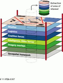
At the heart of the Geospatial Information Infrastructure is the geospatial framework, a compilation of consistent geospatial information sets with known accuracy, quality, and lineage. Together, these sets form a complete picture- and information-intensive view of a military mission area (see Fig. 1).
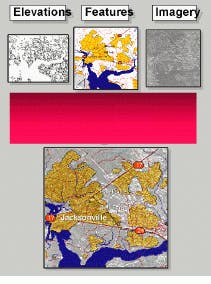
The key set--foundation feature data--forms the base of the GII framework. It includes orthorectified monoscopic and stereoscopic imagery, digital terrain elevation data, and digital nautical charts. Although feature density depends upon the specific geographic region, it generally approximates a traditional 1:50,000 to 1:100,000 scale map and is producible in 1 latitude/longitude cells (see Fig. 2).
Plans call for the Shuttle Radar Topography Mission to generate digital terrain-elevation data between 60 North and South by the year 2000. However, other collection methods for obtaining elevation data are being sought from both military and commercial sources. In the future, additional imagery and intelligence data will be included. Mission-specific data sets enhance the foundation feature data with higher-resolution controlled imagery, elevation, depth information, and vector features.
Commercial technologies
Given the military`s demand for rapid technology deployment, commercial products and technologies have been given a central role in the GII. Although commercial off-the-shelf systems are seen as the best and fastest means to achieve the planned goals, they are not considered the complete solution.
"While many commercial off-the-shelf solutions provide the functionality required, they have been largely stand-alone applications," says Sue Kalweit, NIMA Commercial Technology Opportunities Team leader. In contrast, the driving force behind the NIMA Integrated Products Team (IPT) is to move away from discrete products and toward integrated processes and a flexible set of workgroup tools. "The IPT is about building complete information and business strategies," states Mark Reichardt, IPT production team leader.
To date, commercial progress in advanced geospatial imaging-tool development has been suppressed by the lack of interoperability between vector-based geographical information systems (GIS) and image-based systems. "We are working on these issues in conjunction with industry," declares Kalweit. Working through industry groups such as the Open GIS Consortium (OGC), NIMA`s Commercial Technology Opportunities Team is working to move existing commercial systems to a common, open architecture and to develop solutions that will reduce integration and maintenance costs. NIMA was the first strategic member of the OGC, the industry group responsible for promoting GIS standards development. "Standards and system interoperability are critical to our goal of taking greater advantage of commercial imagery and products," notes Kalweit.
Geospatial prototypes
To help the IPT demonstrate and integrate the capabilities of commercial products, NIMA has built a Geospatial Prototype Facility (GPF) in Bethesda, MD. "Here," says Irv Buck, IPT leader, "we can test, in a controlled environment, each portion of a system, including production, information management, dissemination, and exploitation."
The GPF is divided into classified and unclassified areas; commercial products are initially evaluated in the unclassified area and then are moved into the classified area if successful. "We must demonstrate that the systems will work with real data sources. At the same time, we do not want to limit the number of products we can evaluate because of classification concerns," explains Kalweit.
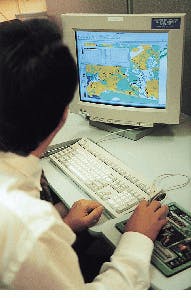
In unclassified demonstrations, imaging-product vendors are responsible for providing hardware, software, and connectivity, although ports to an unclassified 10-Mbit/s Ethernet local-area network are available (see Fig. 3). In the classified area, the GPF has a large complement of custom- and vendor-supplied equipment. For example, the secure collateral network consists of 100-Mbit/s Fast Ethernet and FDDI ports and connectivity to other networks. Network management is handled by a Sun Microsystems SPARC 20 workstation and two Microsoft Windows NT workstations.
Commercial tools
The IPT schedule called for a limited, end-to-end, scalable demonstration of the GII during fall 1997. At the same time, the IPT is expected to provide a road map for the development of a fully operational GII capability. "The basic goal of GII `97 is to see what the commercial world could bring beyond the capabilities of our legacy systems," says Kalweit.
Last May, NIMA awarded seven contracts to industry. One contract was awarded to Autometric Inc. (Alexandria, VA) for its clustered softplotter production system (CSPS)and software. The company`s software accepts image data from both classified and unclassified sources and passes it to the softplotter system for conversion to controlled image base, digital terrain-elevation data, or foundation feature data formats. Three-dimensional (3-D) visualization and analysis system software, called Edge, then generates textured synthetic environments.
"Starting with a global image layer baseline that covers orbital space to below sea level, the 3-D system sequentially adds additional layers of data such as orthorectified images, controlled image base maps, vector products, and other national image transmission format images," says Rob Porter, Autometric vice president of strategic planning. Real-time links to weather imagery and other threat and intelligence databases and sources, such as satellites and aircraft, are also included in the visualization environment. Ultimately, users will be able to simulate flight through the visualization environment in real-time.
At the GPF, the CSPS runs on both Silicon Graphics and Digital Equipment Corp. workstations. Autometric provides four different platform configurations that allow the IPT to compare the benefits of computer power versus graphics capability and to better evaluate hardware requirements and workstation utility.
Another imaging-system vendor, Computing Devices International (Bloomington, MN), received a contract for its Geo-Located MultiSource Exploitation (GLMX) 3-D production system. "GLMX visualizes models extracted from imagery to provide a context layer for annotation of other information," says Roger Lewis, Computing Devices` program marketing manager.
The GLMX system builds 3-D models of buildings directly from two-dimensional image sources. Site models are then combined with map data in the Edge visualization environment for targeting, sensor-simulation, mission planning, and battle visualization. An electronic light table allows users to roam around the images, as well as to zoom into and manipulate particular areas. Feature-extraction techniques include edge detection, line extraction, and image segmentation.
Moreover, the GLMX also supports multiple-sensor (camera) models including central perspective, parallel perspective, and rational polynomial. The rational polynomial form is well-suited to different types of sensing systems, including electro-optic, synthetic aperture radar, infrared, and hand-held cameras. Once a camera model is known, objects in 3-D space can be projected onto its images. A minimum of two different-perspective images are required, although they do not have to be a stereo pair.
Running on a Silicon Graphic`s Extreme workstation, the GLMX supports different software-display formats including Sun Raster, SGI format, and raw raster. Other formats can be handled indirectly using conversion applications from Silicon Graphics` ImageVision Library. GLMX also includes tools for generating QuickTime format movies and HTML documents and can export model files in several formats.
Battle simulations
All the GII `97 systems are being evaluated in a series of hypothetical military scenarios that involve the fictional country "Kartuna." In one scenario, Kartuna is threatened with imminent invasion and requires the immediate evacuation of civilians. In another scenario, an air strike is to be carried out against the aggressor`s command and control facility. A third scenario tests the ability of the GII to rapidly generate mapping resources for a specific crisis area. All the scenarios are conducted according to prepared scripts using the specific tools that would be needed to support the various operations.
Because the ultimate goal of NIMA and the IPT is to serve as a resource for geospatial information, the IPT is producing the GII`s layered database and imagery products from the foundation feature data, controlled image base, and digital terrain-elevation data.
Demonstrate capabilities
To evaluate geospatial imaging and management tools, the GPF/IPT has participated in several interoperability and field demonstrations including the Joint Warrior Interoperability Demonstration (JWID) and the Defense Advanced Research Projects Agency Synthetic Theater of War (STOW) demonstration. The IPT is also participating in the Joint Precision Strike Program`s Rapid Terrain Visualization program. For demonstrations, the IPT is providing generic foundation feature data and a number of mission-specific data sets.
"It`s one thing to show these concepts running on NIMA hardware, such as in JWID and STOW, but now we need to show that we can take these same capabilities to the field and have them operate on warfighter systems," says Army Lt. Col. Steve Kilcullen, team leader for IPT exercises and demonstrations. Some lessons have already been learned from the earlier demonstrations. "We found that not all of the systems could handle the GII foundation data, being hardwired to a particular raster graphic or controlled image base. We need to ensure that the GII capabilities will support the deployed systems across all the services," adds Kilcullen.
The Commercial Technology Opportunities Team is laying plans for the next phase of the effort that will emphasize the networking portion of the infrastructure. "Clearly networks are a centerpiece of our technology infrastructure," says Kalweit, "but for GII `97, we needed to focus on the production and information-tool functionality first. We needed to have these basic applications in place before we could evaluate Internet-level networks." The follow-on GII `98 program will emphasize various high-speed networking technologies and the convergence between GIS and global-positioning-system technology.
FIGURE 1. The fusion of imaging information from different domains provides an integrated view of the military mission space. Data from many sources must be combined into a common geometry and standard set of naming conventions. The data should also be logically deconflicted to furnish a coherent integrated view of the area of interest.
FIGURE 2. The US military is striving to meld the basic components of foundation feature data (FFD) to create a maplike view for use in mission planning and operations. The FFD data include delineations of transportation and drainage networks, geodetic control points, populated places, boundaries, and natural and cultural features of high interest or visibility.
FIGURE 3. To help its Integrated Products Team move away from discrete devices to integrated processes and a flexible set of workgroup tools, the National Imagery and Mapping Agency has set up a Geospatial Prototype Facility in Bethesda, MD. Cartographers at the facility use commercial Geospatial Information Infrastructure packages to produce prototype products on UNIX-based workstations. The products are tested in a controlled environment to demonstrate their capabilities for military imaging applications.
Automated feature extraction speeds mapmaking
Recently, the National Imagery and Mapping Agency (NIMA) Integrated Product Team released its GII Master Plan document, which included information on the architecture, standards, and functional requirements of the Geospatial Information Infrastructure (GII), as well as milestones and time frames for implementation. The plan also included an initial assessment of the GII `97 demonstration, which addressed the balance between technologies and the realities of fielding operational imaging systems to large military forces.
Among the document`s conclusions was that automated feature-extraction technology is not sufficiently mature to support the desired performance requirement for the production of vector feature information. Feature generation will continue to be labor-intensive because interactive digital extraction will still be required in the foreseeable future. Working with industry, NIMA plans to address the problem through increased emphasis on open-source digital information and photogrammetric sources for feature capture.
Communication bandwidth was also cited as a limiting factor in the dissemination of geospatial information, especially for tactical users. This limitation may slow the transition to an all-digital geospatial environment and hinder the submission of value-added data from users, further limiting the effective sharing and reuse of information.
J. H.
Company Information
Autometric Inc.
Alexandria, VA 22312
(703) 658-4450, Fax: (703) 658-4021
Web: www.autometric.com
Computing Devices
International
Bloomington, MN, 55431
(612) 921-6774, Fax: (612) 921-6165
Web: www.cdev.com
Core Software Technology
Pasadena, CA 91105
(818) 796-9155, Fax: (818) 796-8574
Web: www.coresw.com
Digital Equipment Corp.
Maynard, MA 01754
(508) 493-5111, Fax: (508) 493-7374
Web: www.digital.com
DTK-Federal
Chantilly, VA 20151
(703) 222-9194, Fax: (703) 222-8374
Web: www.dtk.com
EMC2 Corp.
Hopkinton, MA 01748
(508) 435-1000, Web: www.emc.com
ESRI
Vienna, VA 22182
(703) 506-9515, Fax: (703) 506-9514
Web: www.esri.com
Laser-Scan USA
Sterling, VA 20164
(703) 709-9306, Fax: (703) 709-8629
Web: www.laser-scan.com
National Image Mapping Agency (NIMA)
Fairfax, VA 22031
(703) 275-8514, Fax: (703) 275-5934
Web: 164.214.2.59
Silicon Graphics Inc.
Mountain View, CA 94043
(800) 800-7441
Web: www.sgi.com
Space Imaging, EOSAT
Thornton, CO 80229
(303) 254-2000, Fax: (303) 254-2215
Web: www.spaceimage.com
Sun Microsystems
Mountain View, CA 94043
(415) 336-2527, Fax: (415) 968-6396
Web: www.sun.com


