Airborne mapping system targets UAVs
Direct georeferencing or rectification of data from airborne imaging systems is especially important to military planners who require such airborne data to be mapped to ground-based coordinate systems. Because the accuracy of this rectification process is critical, these systems use highly calibrated large-format imagers, coupled with rugged computer systems and integrated global positioning systems (GPSs) and inertial navigation systems (INSs).
“In typical airborne mapping systems,” says Kevin Kearney, chief technical officer of Geospatial Systems (GSI; West Henrietta, NY, USA; www.geospatialsystems.com), “cameras must first be calibrated so that any distortion or other artifacts can be compensated for in software. As each image is captured, the camera position and its orientation must also be recoded. While the position of the camera is measured using a GPS system, an INS provides the attitude or orientation of the camera’s principal axes relative to the horizon.”
Pixels can then be referenced to the Earth’s coordinate system and images mosaiced. When formatted in the National Imagery Transmission Format Standard (NITFS), these image data can then be fused with other geospatial data that complies with the NITFS.
“While many airborne mapping systems are deployed in satellite and manned aircraft,” says Kearney, “others are especially tailored for unmanned aerial vehicles and unmanned aerial systems (UAVs/UASs). For example, GSI’s Tactical Airborne Mapping and Surveillance (TAMS) system is composed of a number of large-format, ruggedized, athermal cameras developed by GSI that are coupled to the company’s TerraPix DGX-M sensor management system.
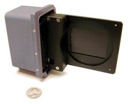
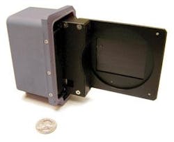
The TAMS system is built on GSI’s cameras that are offered in 2-, 11-, and 39-Mpixel formats. While the 2- and 11-Mpixel cameras are based on Kodak’s interline CCDs, the 39-Mpixel is based on a Kodak full-frame sensor. “Because these large-format image cameras use full-frame imagers from Kodak Image Sensor Solutions (Rochester, NY, USA; www.kodak.com), it requires an external mechanical shutter to capture images. In the design of the KCM39 Kinematic Camera Module (KCM) camera used for its TAMS system, the company has designed a modular curtain shutter (see photo). “Should the shutter fail, it can be easily replaced without the need to open the camera body. This saves both time and money since the shutter can be swapped within a matter of minutes and requires no camera recalibration,” says Kearney.
As images are captured they are transferred from the cameras to the DGX-M controller that comprises a set of PC-104 boards used to store, process, compress, and disseminate image data to a ground station in NITF format. “Using the PC-104 standard, the system can accommodate a number of cameras that may use different interfaces,” says Kearney.
In the TAMS system, images from the cameras are transferred to the AMS using a PC-104 Camera Link board or over Gigabit Ethernet. Captured images are then stored in on-board memory of the system’s PC-104-based CPU and can be compressed using a JPEG 2000 compression board based on a single-chip codec from Analog Devices (Norwood, MA, USA; www.analog.com). This module compresses image data for transmission in NITF format to a remote ground station.
To allow the TAMS to function as a complete airborne mapping and surveillance system, the unit can be interfaced directly to GPS, INS, and digital RF up and downlink units using the system’s digital I/O controller. As NITF images are received by these ground stations, they can be processed by the Leica Photogrammetry Suite from Leica Geosystems (now Erdas; Atlanta, GA, USA; erdas.com), a collection of photogrammetric software that includes tools for orientation and orthorectification.

