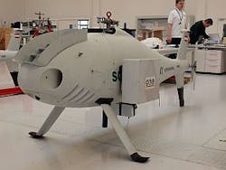
UAV monitoring system uses multispectral camera
Monitoring the soil composition ofagricultural land is important for maximizing crop yields. For large areas, taking ground samples and estimating the soil water status at random locations is time consuming and only provides a sparse sampling of the area. For this reason, Carinthian Tech Research (Villach, Austria), Schiebel GmbH (Vienna, Austria), and Quest Innovations B.V (Middenmeer, the Netherlands) have developed an aerial multispectral imaging system that is both faster and provides full sampling of the area to be examined.
Mounted on a Schiebel Camcopter S-100 UAV, Quest’sCondor-1000 MS5 five-CCD multichannel camera captures three visible channels and two near-infrared NIR channels concurrently. To capture image data, the UAV followed a circular path over a partially snow-covered area containing mixed vegetation. Images were taken during the whole flight at altitudes varying from 150 to 500 ft. The resulting data set consists of a sequence of 107 images, each with five data channels. Before the images can be analyzed and interpreted, they are stitched together into a larger mosaic image.
After image stitching, the Normalized Difference Vegetation Index (NDVI), a standard coefficient originally developed to classify LANDSAT images, was calculated and used to quantify the presence of living vegetation. Since leaves strongly absorb red light from 600 to 700 nm and strongly reflect NIR from 650 to 1100 nm, then if there is more reflected radiation in NIR wavelengths than in red wavelengths, vegetation is more likely to be dense where NIR radiation is detected.
-- Posted byVision Systems Design
