3D Laser Line Profiling System Details Safety of Road Pavement
Assessing and maintaining the condition of pavement on high-speed roads, such as highways, is an important quality and safety issue. But evaluating the condition of thousands of miles of pavement is a daunting undertaking. That’s why governments deploy automated inspection systems to collect and analyze data.
And a common method of automation relies on machine vision. Specifically, laser line devices and cameras capture image data on pavement conditions transversely, or across the lane, at regular intervals. Algorithms analyze the information to calculate metrics on numerous safety issues.
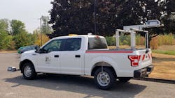
These vision systems often are mounted on vehicles, such as pickup trucks, and capture information on pavement quality as the vehicles are driven at normal speeds, often up to 60 mph, on the road undergoing inspection.
Machine Vision Highlights Safety Issues
The safety issues these tools evaluate include:
- Rutting, which is a linear and longitudinal depression in the wheel path on a road. When ruts fill with rainwater, they can be dangerous because the water prevents a vehicle’s tires from gripping the pavement properly, leading to hydroplaning.
- Cracking, which occurs anywhere on the road and is the result of numerous issues, such as heavy loads driven on the roads or inclement weather.
- Edge of lane drop-off. A steep or perpendicular drop-off between the road and the shoulder can be dangerous if a motorist pulls off the road or reenters it too quickly.
- Condition of lane markings, which are an important safety feature because they define the path drivers should follow.
Related: Pavement Management Systems Needed to Keep Roads Safe
3D Laser-Line Profiler
Ames Engineering (Ames, IA, USA) is one company selling this type of application. The company’s Transverse Profiling System collects information on the entire lane width (13 ft, or 4 m) using a single laser and high-speed 3D camera.
Available in two versions, the system collects either 2,048 points per profile (2K version) or 4,096 points per profile (4K version). Longitudinal spacing between the profile views, or slice of pavement, can be set between 0.25-0.5 in for the 2K version and 0.1-0.2 in for the 4K version.
The camera, lens, bandpass filter, and laser line device are configured by HyMIT (Austin, TX, USA) and installed in a weather-proof enclosure made of Acrylonitrile Butadiene Styrene (ABS) plastic.
The filter is necessary to screen out excessive sunlight, according to Robin Huang, founder and owner of HyMIT, which develops custom-built 3D profiling solutions to assess pavement conditions and has customers in 16 countries.
The laser included in HyMIT’s system is more powerful than those used indoors for product inspection, he says. Though Huang did not provide details on the laser in Ames Engineering’s application, he says the lasers used in HyMIT’s pavement-inspection systems range from 1,000 to 10,000 milliwatts.
Related: 3D Imaging Detects Defects in Railroad Rails
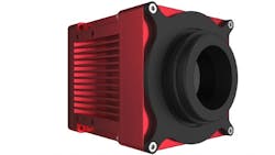
For Ames Engineering’s system, the 3D camera is one of several models from the Series C6 from AT Sensors (formerly AT-Automation Technology, Bad Oldesloe, Germany).
Earlier models of the product included AT Sensor’s earlier-generation camera series, the C4.
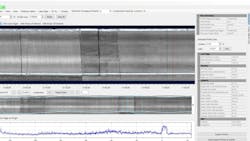
The 3D laser line device transmits data to software loaded on a rugged laptop with a bright screen designed for reading in sunlight.
Collecting and Analyzing Image Data
The Transverse Profile System works like this: A laser line device projects a line across the pavement at regular intervals. A high-speed camera captures images of that line at either 2,048 data points per profile or 4,096 data points per profile, depending on the camera. The laser/camera combination captures the entire span of roadway, or one lane of traffic, with a single laser and camera.
A 3D profiling system using one camera and laser is unusual, compared with other systems on the market for transverse pavement inspection, according to Huang. “Most road measuring systems consist of two sensors due to the width of the road, each covering about 2 meters on each side. However, the problem here is that the complexity of having to install two sensors side by side creates a gap in the middle of the road,” he explains.
Related: Machine Vision Battery Tray Inspection System Uses 3D Scanning
Based on deformations in the transverse line, which is created with those data points, algorithms calculate the average depth of the ruts. Typically, ruts of more than 0.5 in depth are considered bad enough to trigger action such as repair, according to Jon Klatt, general manager at Ames Engineering.
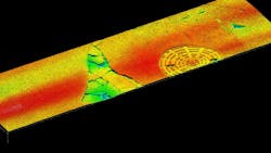
The camera also produces 3D intensity and 3D model views of the pavement segments, which officials at transportation departments can review using software from Ames Engineering. The collected data can also be used with software from other companies to provide calculations on cracks or lane drop-offs.
HyMIT provided the sensor and control and data acquisition software to Ames Engineering, which developed data analysis algorithms and front-end software for users.
Ames Engineering also integrated the sensor and software with location information from a GPS receiver, which is mounted on the top of the truck.
A network hub in the truck allows communication between components—software, 3D profiler, and GPS—via an Ethernet connection.
Using Data on Pavement Ruts in R & D
Transportation officials use the pavement condition information to make repair and replacement decisions and to carry out R & D activities.
For example, the Illinois Department of Transportation (Springfield, IL, USA) uses the transverse profiler from Ames Engineering in research projects, including those to assess the durability of aggregates, or granular materials, in asphalt-based pavement mixes.
In one ongoing research project, for example, the department wants to find a locally sourced granular material to use in asphalt pavement mixes for selected state roads in rural areas. While traffic from automobiles may be light, semitrucks often use these roads. “When you're thinking about pavement design, an actual everyday sedan or even a pickup, those barely do any damage to a pavement structure. It’s the semis that are really heavy. That’s where all the damage comes from,” says John Senger, bureau chief of research for the Illinois DOT.
Related: How Drexel University Researchers Improved the Inspection of Concrete Structures
Currently, Illinois buys granular materials from other nearby states for these roads, but it would save money if it sourced materials from within its borders. However, Illinois first needs to develop a durable mix through research. Stones that are too soft will become smooth over time from the repetition of vehicles driving over the pavement. Once the stones lose their angular edges, the pavement start to will break down, Senger explains.
The transverse profiler “is essentially a research tool to help us quantify how well pavements are responding to vehicle loading,” Senger says. “The goal of which is to improve the roads in Illinois by coming up with better pavement formulas,” he says.
About the Author
Linda Wilson
Editor in Chief
Linda Wilson joined the team at Vision Systems Design in 2022. She has more than 25 years of experience in B2B publishing and has written for numerous publications, including Modern Healthcare, InformationWeek, Computerworld, Health Data Management, and many others. Before joining VSD, she was the senior editor at Medical Laboratory Observer, a sister publication to VSD.


