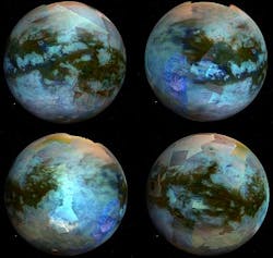
Research team pieces together the surface of Titan moon
An international team led by researchers at the University of Nantes (Nantes, France) has pieced together images gathered over six years by the Cassini space mission to create a global mosaic of the surface of Titan, the largest moon of Saturn, using a spectrometer.
To do so, the team compiled all the infrared images acquired by the Visual and Infrared Mapping Spectrometer (VIMS) during Cassini’s first 70 flybys of Titan.
Cassini has made 78 flybys of Titan since it arrived in orbit around Saturn in July 2004. A further 48 flybys are planned up to 2017. But to date, VIMS has only had a few opportunities to capture images of Titan with a high spatial resolution.
Hence the global map created by the French team currently shows some regions of Titan in more detail than others, because they were created using low-resolution images as a background with the high-resolution images overlaid onto them.
In addition to improving spatial coverage, future mapping will allow the observation of seasonal changes in both the atmosphere and the surface of the moon.
-- Posted by Vision Systems Design
