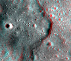
NASA publishes 3-D images of the moon
The camera aboard NASA's Lunar Reconnaissance Orbiter is acquiring high-resolution (0.5 to 2 meters/pixel) stereo images of the moon.
The images are being processed by a system developed by engineers from the Lunar Reconnaissance Orbiter Camera Narrow Angle Camera (LROC NAC) team from the University of Arizona (Tucson, AZ, USA) and Arizona State University (Phoenix, AZ, USA) which automatically generates anaglyphs from the stereo pairs that can be viewed in 3-D using red-blue/green glasses.
The LROC acquires stereo images by targeting a location on the ground and taking an image from one angle on one orbit, and from a different angle on a subsequent orbit.
Anaglyphs are used to better understand the 3-D structure of the lunar surface. The LROC NAC anaglyphs make lunar features such as craters, volcanic flows, lava tubes and tectonic features jump out in 3-D.
At the present time, several anaglyphs have been published. These include an image of cliffs on the moon which are found mostly in the highlands, a roughly 12-kilometer-diameter crater, and an ancient channel formed as massive eruptions of lava once poured across the surface of the moon.
More anaglyphs will be released through the LROC web site and the NASA LRO web site as they become available.
Related items from Vision Systems Design that you might also find of interest.
1. Imaging algorithms map out the Moon
Computer scientists at NASA's Ames Research Center (Moffett Field, CA, USA) have used image processing algorithms to transform legacy data from the Apollo Metric Camera onboard the Apollo 15, 16 and 17 spacecraft into an immersive 3-D mosaic map of a part of the moon.
2. Titanium treasure trove found on the Moon
A team from the School of Earth and Space Exploration at Arizona State University (Tempe, AZ, USA) has created a map of the Moon that shows areas rich in titanium ores.
3. Moon mapping produces high-resolution models on 100-m scale
The highest resolution near-global topographic map of the Moon ever created has been released by the Arizona State University (Phoenix, AZ, USA) team that oversees the imaging system on board NASA’s Lunar Reconnaissance Orbiter (LRO).
-- Dave Wilson, Senior Editor, Vision Systems Design
